Standing on the banks of the River Parrett one afternoon, there seemed something not quite right, something missing. In memory there had been a tributary running from the river, not the River Yeo, but something running toward the town.
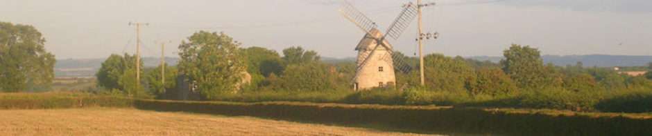
In memory, there had been a regatta day, Langport Splash it had been called, and there had been a challenge to paddle a raft that was called The Unsailable Avalon. The raft consisted of plastic barrels lashed to planks to which a deck chair had been fixed. The winner would be the person who could board the raft and paddle it up the river. After a number of attempts, my father, who had grown up on the banks of the River Thames at Chiswick, had swum out to the raft, climbed aboard and propelled it with complete ease – his sangfroid had been such that he had kept a cigarette between his lips and had stopped for a smoke midstream, to the laughter of those who stood on the banks watching his progress. In memory, there was water on both sides of the land on which we stood. How could it have been so, anyone who knows Langport will tell you that there is only one river in the town.
Buying an old Ordnance Survey map, a 1930 edition that had been revised in 1946, there was a suggestion that the memory might not be mistaken. There had indeed been two rivers through the town.
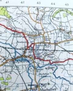
Asking my mother, whose family are at least four centuries in the parish, she recalled the “catchwater” that left the River Parrett, flowed through the town under Little Bow Bridge, and then rejoined the river.
Having enough information for an Internet search produced detail of what my mother had described.
From the Parrett south of the town a ditch, known as the Portlake rhine by 1526 and later as the Catchwater, ran through the town and north-west over the Langport ‘moors’ to rejoin the river. The portion through the ‘moors’ was filled in 1966 and south of the Little Bow bridge it has been covered by a car park. The Back river, known as a common rhine in 1470–1, runs west from the Catchwater south of the town and enters the Parrett above the Great Bow bridge.
The other memory of that regatta day was Lily the Pink being played over the public address system. Were that to be true, then if the song was Number One at Christmas 1968, then perhaps the Splash had been the summer of 1969. The book Langport and Huish Through Time includes a picture of the Catchwater before it was culverted, suggesting this took place in the 1960s; were it later, then the memory of there being a river on two sides in the summer of 1969 might be one not misremembered.
Hmm, Reading down that passage and it seems it was assigned to be a sewer for houses higher up.
I found a copy I’ll try to include from a Old Maps site that shows a waterway making a triangle of the town. But the bit I found interesting was the entrenchments from the civil war were still high enough in 1870 to show on the survey.
https://www.old-maps.co.uk/#/Map/342676/127428/12/100302
I have no doubt it carried much wastewater – it is now sluiced at the southern end and had little water in it when I checked today.
I realise part of my confusion arose from conflating the building of the shops and the car park with the opening up of the are called Cocklemoor – there were two decades between the two!
I hadn’t noticed the entrenchments on maps before – I shall investigate further!
There seems to be a lot in the grounds of Hurds Hill house. But they could be from a position the attackers assumed. And that’s the only one I can see from Google earth that still exists. It’s the outer boundary of the current garden it seems. But it could also be the cross river defence too.
I’m not sure from what period the Hurd’s Hill earthworks might date, perhaps much earlier than the Seventeenth Century trenches at the other side of the town?
Given it’s the highest bit it could have settlement evidence going back quite a distance. But I expect whatever is there from the pre Roman, and perhaps Roman would be incorporated with Civil War earthworks which might make it a interesting prospect/nightmare depending on ones outlook.
If you remember how Cromwell went about taking the Old English towns in Ireland, Drogheda, Wexford, Clonmel. Well the tactics were well developed on the continent and England. You would have a town, or a fortified place that would erect further ‘modern’ defences. Earthworks really. Then the attacker would tootle up and build another set of works outside and well with range of the guns, preferably above. What the couldn’t do was leave it behind their lines so it had to be rooted out. They discovered ‘gabions’ were more useful against guns than the medieval walls. The ball would punch in like you hitting a pillow. But the town could only survive if it was build over a vast cellar network. Think Stalingrad.